Ekiti State Governor, Mr. Biodun Oyebanji, on Wednesday launched a groundbreaking 3D aerial mapping project designed to transform land administration, boost investment, and support infrastructural development through the creation of a modern geospatial database.
The initiative, flagged off at the Ekiti Agro-Allied International Cargo Airport in Ado-Ekiti, is a major step in the state’s drive toward digital governance and efficient land management.
Describing the project as a “game changer,” Governor Oyebanji said it will enhance transparency, curb fraudulent land transactions, and increase property security for residents and investors.
“When this is completed, it will open the door for more investment in Ekiti. The era of one land being sold to multiple people will end, and land grabbing will become a thing of the past,” the governor said. “Investors will no longer need to visit the Surveyor-General’s office; they’ll be able to locate any land or property with the click of a button. It’s a revolution, and I’m glad it’s happening now.”
The governor emphasized that the mapping exercise would create reliable and accessible land records, reinforcing confidence among investors and aiding sustainable urban planning.
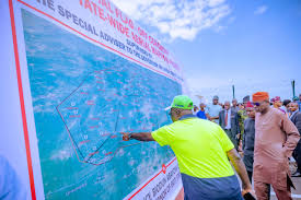
Special Adviser to the Governor on Lands, Survey, and e-GIS, Prof. James Olaleye, said the exercise signals the start of a broader effort to modernize land governance using advanced geospatial technologies. He explained that the mapping aircraft will fly at low altitudes to capture comprehensive data across the state’s landmass, with the exercise expected to last one month.
Surveyor Olajugba Oluropo, the project contractor, walked government officials through the mapping process and the technology on board the aircraft. He assured Governor Oyebanji of a timely and high-standard delivery.
The flag-off ceremony was attended by top government officials including Deputy Governor Chief (Mrs) Monisade Afuye; Secretary to the State Government, Prof. Habibat Adubiaro; Head of Service, Dr (Mrs) Folakemi Olomojobi; and members of the State Executive Council. Traditional rulers present included the Chairman of the Council of Traditional Rulers and Olojudo of Ido-Ekiti, HRM Oba Ilori Faboro, and the Ewi of Ado-Ekiti, HRM Oba Adeyemo Adejugbe, Aladesanmi III.
Following the event, the mapping aircraft took off, marking the beginning of what officials say is a transformative step toward a digital future in land governance for Ekiti State.
Edited by Nzubechukwu Eze.


